

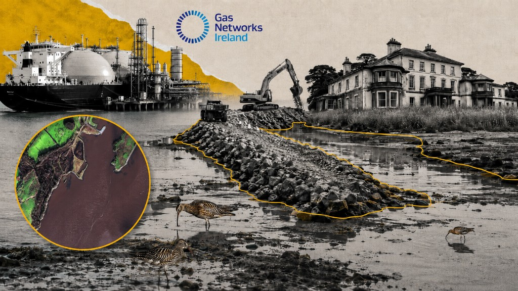
State anchoring its flagship emergency energy asset, in County Clare, to an environmental crime scene and a non-existent root of title
The coastal topography of County Clare is frequently reduced to a simplistic binary: the dramatic verticality of the western cliffs or the stark, fractured limestone of the Burren. Yet, to the southwest, stretching along the coast road from Ballyea to Labasheeda, the landscape takes on an altogether quieter, more liminal character. Here, the Shannon Estuary encroaches upon rolling drumlins that taper off toward expansive mudflats. These vast intertidal tracts, rhythmically submerged and unveiled by the inexorable pull of the Atlantic tide, sustain a dense, taciturn ecology. The glaucous mud, slick and polished, bears the intricate calligraphy of curlews and redshanks probing for hidden lugworms and tiny mud snails, while vast flocks of dunlin perform their aerial undulations over the grey channels in silent unison. At low water, the silt assumes a strange, metallic, almost iridescent gloss under the shifting sky, coated in microscopic algal mats that form the invisible trophic foundation for millions of burrowing amphipods and the brent geese that frequent these brackish shallows. It is a highly specialised landscape of transition, where the river’s slow deposition of sediment creates a quiet but vital wilderness out in the geographic margins.
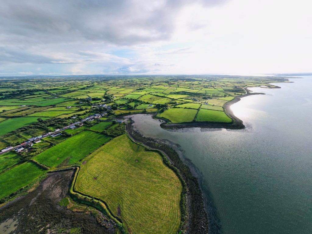
Labasheeda, derived from the Irish Leaba an Síoda, meaning “the bed of silk”, remains a scenic, contemplative village, largely bypassed by the relentless commercial expansion of recent decades. From its recently redeveloped pier, one observes the jarring industrial outlines of Aughinish Alumina and the Tarbert Power Station across the water—the north Kerry coastline sitting so close it creates an illusion of proximity that belies the ecological divide, separated by approximately four kilometres of treacherous current as the crow flies.
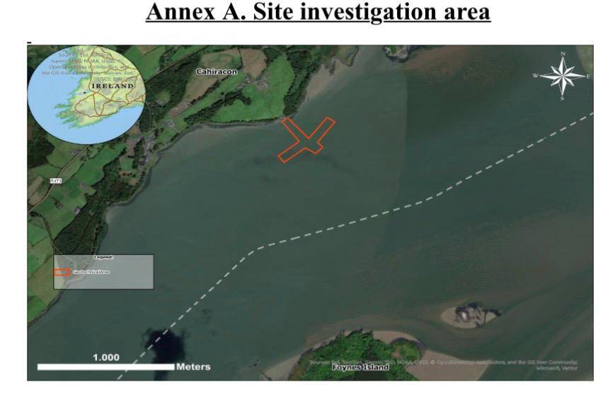
Just a few miles before this ‘bed of silk’ stands Cahercon House, another idyll, an imposing estate whose lands have been selected for a new Floating Storage and Regasification Unit (FSRU) by Gas Networks Ireland. Cahercon’s history is steeped in a darker, more fraught legacy; once the seat of the notorious Vandeleur family, whose tenure during the peak years of the Great Famine is historically associated with the eviction and displacement of approximately 20,000 people, the estate eventually passed to the Salesian Order, which operated a secondary school there until its closure and amalgamation in 2002.
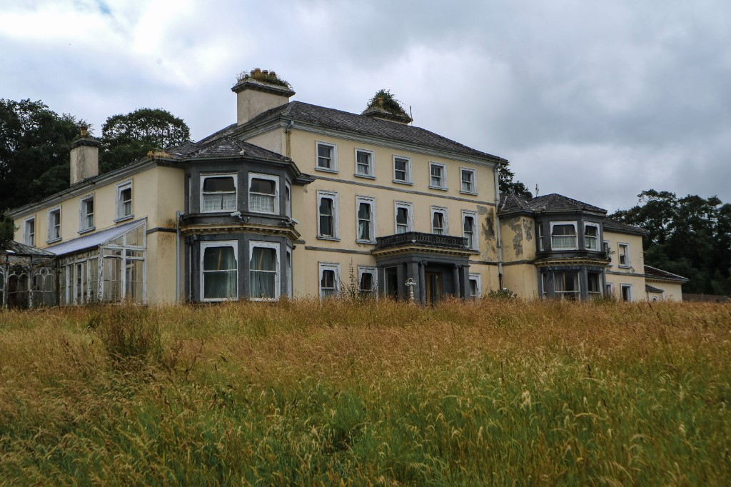
It was subsequently acquired by the Whelan Group, who deemed this isolated shoreline an apt location for an explosives factory. This corporate endeavour initiated a bitter, ten-year planning siege that stretched from 1999 to 2009, long before the State’s modern energy apparatus cast its eyes on the same grey banks. Trading as Shannon Explosives Ltd, the developers sought to plant a €10 million commercial facility for the importation, storage, and manufacture of commercial explosives and blasting agents on this exact footprint.
The local landscape, typically defined by little more than shifting Atlantic weather and the rhythmic hum of the estuary, rapidly became a tactical administrative battleground. The Kildysart Explosives Factory Opposition Group later solidified into a permanent civic structure as Cairde Chill an Disirt Teo which was supported in its efforts by An Taisce and Friends of the Irish Environment contesting the development up every statutory tier. Their objections were grounded in perceived threats to public health and the material risks that an industrial hazard complex posed to the deep-water shipping lanes of the Shannon. Though An Bord Pleanála initially refused planning permission in 2003, it ultimately granted a highly conditional approval in September 2009, just as the wider domestic economy collapsed into structural insolvency. The project was abandoned, but the physical transgression remained inside the estate grounds.
The estate retains a permanent, heavy memory of that era, visible in the stark juxtaposition of fractured rock against soft alluvial mud. The extraction pit itself held a dual status; while the internal pit was a registered quarry under older statutory frameworks such as Section 261 of the Planning and Development Act 2000, the true transgression was the deliberate, unlawful disposal of heavy industrial material. The developer openly admitted using these heavy quarry stones, hauling them down internal tracks to execute gigantic, unpermitted coastal infilling right on the shoreline. Massive limestone blocks were dumped straight into the sensitive intertidal habitat, tearing through the delicate algal mats and embedding themselves deeply into the ancient estuarine silt.
This crude engineering established a hard-rock platform footprint of approximately 0.4 hectares (1.0 acre), while the extended ecological disruption zone swallowed 4.2 hectares (10.38 acres) of the surrounding foreshore, permanently altering the local hydrology where the tides pool and swirl. In 2004, the Southern Regional Fisheries Board successfully secured a conviction against Shannon Explosives Ltd for this illegal coastal infilling over protected intertidal mudflats. Yet, the state’s regulatory response was telling in its real insignificance: a nominal summary fine of €1,500 was handed down, and the actual remediation of the foreshore has never been enforced.
Anticipating future litigation, the developers or the State may well argue as a defensive measure that specific provisions of the Planning and Development Acts did not apply to these marine works at the precise time of the infraction. Nevertheless, the rock platform remains there today within the geographical boundaries of the Lower River Shannon Special Area of Conservation (SAC) and the River Shannon and River Fergus Estuaries Special Protection Area (SPA): a grey, concrete promontory cutting stubbornly into the silt, its angular edges slowly gathering weed and barnacles.
This unresolved physical legacy now intersects with Gas Networks Ireland’s proposed €1 billion FSRU project, which the state seeks to fast-track through emergency planning pathways to circumvent standard public oversight. Due to the scale and nature of the proposed liquefied gas volumes, the development would be classified as a Seveso III Upper Tier major hazard complex, triggering stringent statutory obligations of public safety separations and major accident hazard prevention.
Here, a profound epistemological dissonance emerges between the administrative record and the physical reality. An examination of Folio CE947, the precise root title required to anchor the modern pipeline’s landfall reveals a systemic divergence between digital cartography and the legal parchment. The text register records that the root title of Folio CE947 is currently held directly in the private name of Kate (Kathleen) Donlan, wife of Tony Donlan, a principal director associated with the United Metals and UMR Recycling Group. Holding the root title of this critical landing strip personally rather than within a limited liability corporate shell represents a highly exposed positioning, perhaps signalling an intent to lease the footprint directly back to the State for a substantial private return.
Yet the actual expansion of the boundary lines onto the water occurred entirely outside the scope of that original title-deed transaction. Just a few weeks ago, the official digital land registry map for this shoreline showed absolutely nothing extending into the estuary; the private property boundary polygon stopped precisely at the high-water mark, leaving the public waters untouched and open to the tide. By a striking coincidence of timing, on May 22, 2026, precisely as public and political attention began focusing on the project’s upcoming phases, a system update occurred on Tailte Éireann’s platform. This real-time alteration, executed via the eRegistration portal into the ITRIS database system, generated a precise 4.80-hectare boundary polygon out of nowhere on the digital map layer, claiming private ownership over state-owned foreshore and directly enveloping the exact footprint of that old, illegal 2004 limestone rock dump.
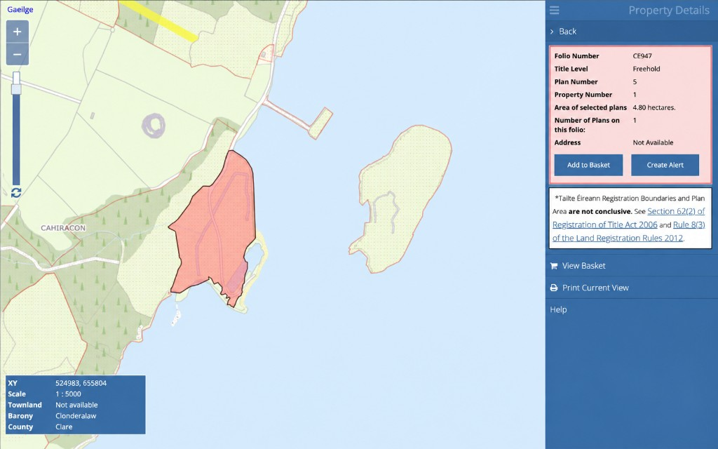
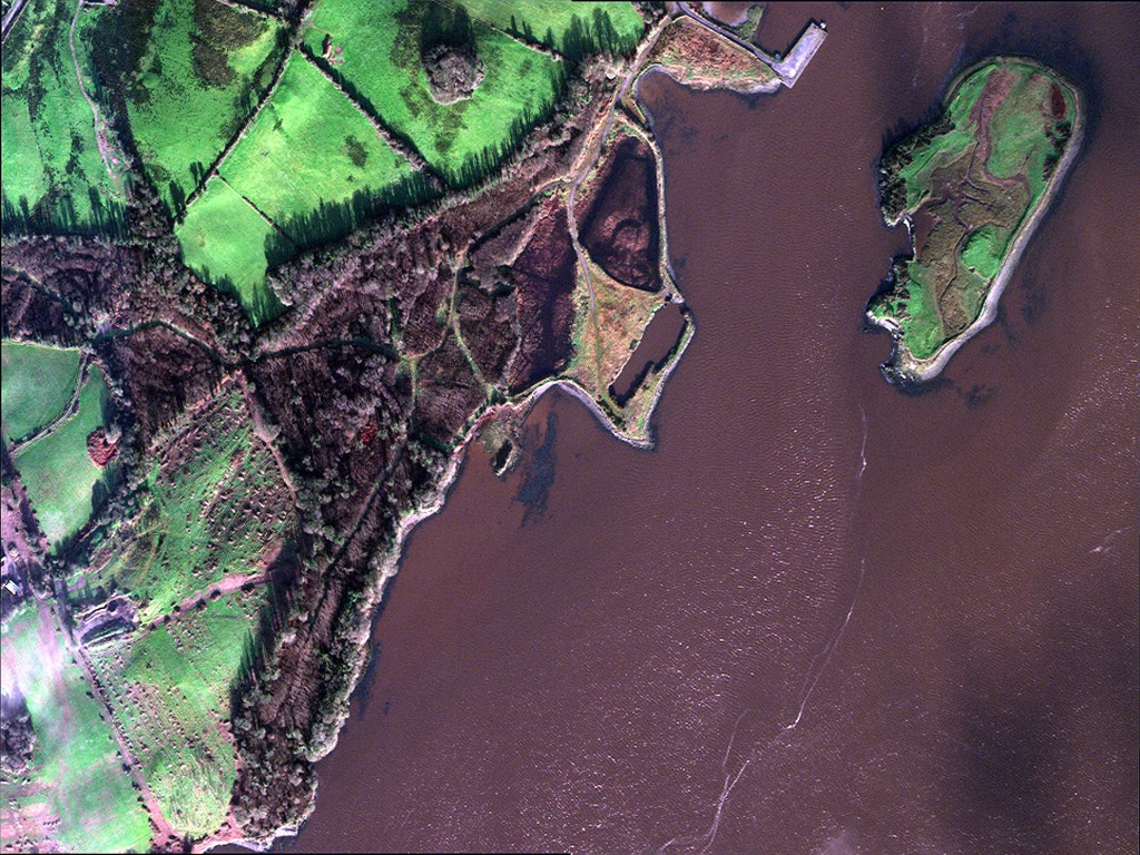

This digital expansion, which may well be an administrative error or a routine database mistake on the part of the land registry rather than a deliberate, targeted action for the project, nonetheless generates a profound legal fiction. While the map mistakenly grew to cover the compromised foreshore, the official written deed stays completely silent. If one pulls the certified written ledger for Folio CE947, the mandatory column designated for certified acreage remains a stark, empty white void, a physical and administrative silence in the face of an industrial claim on public waters.
While Section 85 of the Registration of Title Act 1964 dictates that Ireland operates a non-conclusive boundary system, leaving the text record silent on a massive industrial marine baseline reveals a fatal vulnerability. To record a definitive hectarage in black and white, the land registry, under the Foreshore Act 1933, requires a verified root of title showing how public marine territory legally passed from the State to a private citizen. Because this newly claimed map footprint is built literally upon a criminally prosecuted, unremediated environmental infraction, no such root of title exists; the digital lines have shifted on the screen due to an administrative oversight, but the paper deed refuses to legitimise the claim to the foreshore. It leaves the arrangement exposed to the risk of a formal administrative challenge via Tailte Éireann or an immediate complaint to the Ombudsman, while inviting intense scrutiny and potential criminal liability review regarding how a private individual can suddenly claim public waters on a screen while the written deed stays entirely blank.
The State’s accelerated framework is further complicated by severe exposure to the European Union’s Environmental Impact Assessment Directive, where the legal arguments mirror the fragmented nature of the land itself. There are strong indications of project splitting across the broader estate parcels, which completely dwarf the compromised footprint of Folio CE947. The EIA Directive explicitly prohibits fragmenting interconnected industrial works into separate planning tracks to avoid a consolidated environmental review. If the separate onshore activities across the wider estate and the State’s adjacent €1 billion gas reserve share a localised environmental zone of influence, attempting to isolate them into separate planning tracks constitutes an explicit breach of the EIA Directive under the precedent established in O’Grianna v An Bord Pleanála.
Furthermore, under the Foreshore Act 1933, the State countrywide holds absolute ownership of the marine baseline up to the ordinary high-water mark. If the land registry’s map boundary erroneously expanded into the estuary without an explicit, formal State grant or lease confirming a legitimate transfer of public territory, the mapping remains entirely invalid. GNI cannot make use of emergency infrastructure pathways to procure land from a private individual who lacks legal ownership of it.
In an effort to insulate the €1 billion project from these historical and proprietary liabilities, preliminary promotional infographics from Gas Networks Ireland suggest that the final pipeline route and the FSRU mooring will not sit directly on top of the 2004 infill platform. Instead, current designs indicate that the infrastructure corridor will cross the shoreline approximately 200 metres to the west. Under European environmental law, this minor geographic buffer is an absolute delusion, legally. Under Article 6(3) of the Habitats Directive, as interpreted by the Court of Justice of the European Union in Sweetman v. An Bord Pleanála, any nearshore dredging, trenching, or civil engineering falls squarely within the immediate ecological zone of influence of the unremediated 2004 infraction.
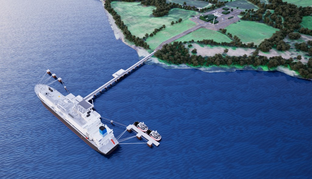
GNI is legally compelled under Section 37E of the Planning and Development Act 2000 to establish an objective and verifiably accurate environmental baseline. The forthcoming Environmental Impact Assessment Report must explicitly evaluate the cumulative impact of its new construction alongside the existing, permanent ecological degradation of the intertidal mudflats and protected SPA habitats. Omitting this critical baseline introduces a severe vulnerability to material and, let’s be clear, perhaps fraudulent, misrepresentation.
Furthermore, under the Environmental Liability Directive and the Polluter Pays principle, by structurally relying on Folio CE947 to anchor its infrastructure corridor, the state inadvertently risks assuming joint liability for this historical damage, legally entangling itself in an obligation to fully remediate a past environmental infraction before a single pipe can be laid.
It appears the State has anchored its flagship emergency energy asset to a documented environmental crime scene and a non-existent root of title.
The last word, and the national perspective, goes to veteran An Taisce activist, Ian Lumley:
“The quiet, ecologically rich Shannon Estuary between Kildysart, Labasheeda and Cahercon — defined by internationally protected mudflats, deep-water shipping, a legacy of environmental damage, and a remarkable history of local campaigns including Aughinish Alumina, Shannon LNG and the Kildysart explosives factory — is precisely the kind of landscape where the State, and a billion euro gas facility, risk provoking another Corrib-Gas-style campaign-débacle.”
As the evening tide slips back down the estuary, exposing once more the slick, gleaming ribs of the mudflats and the ancient, undisturbed rhythm of the wading curlews and redshanks, the quiet of the village feels increasingly fragile. The weight of Cahercon’s past, from the historical clearances of the nineteenth century to the modern, bloodless lines shifting across digital maps, remains heavy on this shore. For those who watch these waters, the true measure of the project will not be found in corporate assurances of national security, but in the enduring silhouette of an unremediated rock platform—a crude, man-made shoreline feature now masquerading as legitimate coastal infrastructure, a silent monument to an unpunished infraction that the mud could not bury.
